


 Articulo en XML
 Referencias del artículo
 Enviar articulo por email
 Citado por SciELO
  Similares en
SciELO
Similares en
SciELO  uBio
uBio 
 Permalink
Interciencia
versión impresa ISSN 0378-1844
INCI v.26 n.8 Caracas ago. 2001
Nancy D. Kingsbury
Nancy D. Kingsbury. Ph.D. in Geography, York University, Canada. Post-Doctoral Fellow, American Association for the Advancement of Science. Address: 5759 Avenue de l’Esplanade, H2T 2Z9 Montreal, Canada. e-mail: kingsbur@web.net.
Resumen
Aunque se ha afirmado que la reciente deforestación en la Gran Sabana es resultado de la intensificación de la rotación de cultivos, no se han aportado datos en comunidades específicas sobre la tasa de cambio de vegetación y uso de la tierra. La elaboración de mapas de vegetación y uso de la tierra en Kavanayen, la mayor comunidad indígena en la Gran Sabana, y su comparación con datos anteriores similares indican que en áreas de cultivo intensivo ha habido efectivamente una pérdida sustancial de bosques y desviación hacia vegetación secundaria no boscosa. La deforestación en estos valles está directamente asociada con la agricultura intensiva y la reducción del período de barbecho, e indirectamente con el uso incrementado de fuego que acompaña al cultivo y el aumento de vegetación secundaria combustible. Cambios en la cultura indígena como aumento en el tamaño y densidad de la población y, para algunos cultivadores, cambios en las caraterísticas de selección de sitios cultivables, los cuales enfatizan ahora aspectos logísticos, en oposición a los factores ambientales más tradicionales, se relacionan íntimamente con el paso a cultivos más intensos espacial y temporalmente, y la deforestación resultante en el período de barbecho.
Summary
Though it has been widely asserted that recent deforestation in the Gran Sabana is a result of intensified shifting cultivation, no supporting community-specific data on rates of vegetation and land use changes has previously been provided. Mapping of vegetation and land use in Kavanayén, the largest indigenous community in the Gran Sabana, and comparison with similar earlier data, indicate that in areas of intensive cultivation there has in fact been substantial forest loss and deflection to secondary non-forest vegetation. The deforestation in these valleys is directly associated with intensive agriculture and abbreviation of the fallow period and indirectly with the increasing use of fire that accompanies cultivation and the increase in combustible secondary vegetation. Changes in the indigenous culture, namely, increases in population size and density and, for some cultivators, changes in agricultural site selection characteristics that now emphasize logistical as opposed to the more traditional environmental factors, are intimately connected with the move to more spatially and temporally intensified cultivation and the resultant deforestation in the fallow period.
Resumo
Ainda que se tem afirmado que a recente devastação na Gran Sabana é resultado da intensificação da rotação de cultivos, não aportaram dados em comunidades específicas sobre a taxa de mudança de vegetação e uso da terra. A elaboração de mapas de vegetação e uso da terra em Kavanayen, a maior comunidade indígena na Gran Sabana, e sua comparação com dados anteriores similares indicam que nas áreas de cultivo intensivo tem havido efetivamente uma perda substancial de florestas (bosques) e o desvio para a vegetação secundária não florestal. A devastação nestes vales está diretamente associada com a agricultura intensiva e a redução do período de barbecho, e indiretamente com o uso incrementado do fogo que acompanha ao cultivo e o aumento da vegetação secundária combustível. Mudanças na cultura indígena como aumento no tamanho e densidade da população e, para alguns cultivadores, mudanças nas características de seleção de lugares cultiváveis, os quais enfatizam agora aspectos logísticos, em oposição aos fatores ambientais mais tradicionais, se relacionam intimamente com a passagem aos cultivos mais intensos espacial e temporalmente, e a devastação resultante no período de barbecho.
KEYWORDS / Shifting Cultivation / Pemón Amerindians / Deforestation / Acculturation /
Recibido:13/02/2001. Modificado: 06/07/2001. Aceptado: 19/07/2001To even the most casual observer, it appears that wide-scale deforestation has recently occurred in the Gran Sabana. For the Pemón Amerindians, who have occupied the Gran Sabana for at least several centuries, the forests are the primary natural resource. They are the location of their conucos (shifting cultivation fields) and the source of game animals. Given the extreme infertility of savanna soils (Kingsbury 1999) and their unsuitability for cultivation, deforestation thus has potentially profound impacts on Pemón subsistence, as well as the obvious ecological impacts such as loss of biodiversity. The larger Venezuelan society is also affected as the efficiency of other resource use in the region, such as the generation of hydro-electric power, requires stability of the hydrological regime that results from the overall maintenance of forest cover.
While some of the deforestation –e.g., numerous dead, blackened tree stumps in fields of otherwise pure savanna– is likely the result of catastrophic fires (Kingsbury 1999), it has been asserted that other deforestation is the result of a combination of the region’s particular ecological characteristics, identified by some authors as its "ecological fragility" and as a result of intensified shifting cultivation by the indigenous population of the region, the Pemón.
Fölster (1986) has suggested that spontaneous vegetation degeneration is occurring primarily as a result of declining soil fertility and chemical and hydrological stress. This process has also been tied to shifting cultivation. It has been suggested (Dezzeo, 1994) that after a field is cut in primary forest, "an authentic, although not very vigorous secondary succession" takes place. However after a second round of cultivation, the successional vegetation is either "matorral" ("scrub" or "brush") or a secondary forest in transition to matorral due to an unspecified "degradation in the regeneration process."
It has also been proposed (Dezzeo, 1994; Elcoro and Vera, 1986; Morales and Gorzula, 1986) that forest displacement by savanna is a result of the region’s "ecological fragility" which is principally related to high susceptibility to erosion and edaphic conditions such as highly acidic soils, low concentrations of soil nutrients and low Ca/Al ratios. Taken together, it is suggested that these factors result in marginal chemical and hydrological conditions (Elcoro and Vera, 1986) resulting in a slow rate of forest re-establishment after disturbance (Morales and Gorzula, 1986) and frequent forest transformation to savanna.
The evidence for attributing the slow rate of forest re-establishment to marginal conditions is indirect. There have been few surveys of disturbed sites and no comparisons of edaphic conditions in undisturbed and disturbed sites where forest has been replaced by savanna. Rather, this theory has been proposed by connecting various observations: accounts and observations of deforestation and savanna extension with analyses that indicate acidic soils, low soil fertility and high levels of soil aluminum, and; observations of intensified shifting cultivation.
Previously no community specific data on the rate of forest re-establishment or forest deflection to savanna after cultivation or on changes in vegetation cover and land use over time have been provided to support these assertions. This paper presents such data and examines the role of agriculturalists in the changing ecology of the region and the role of changes in indigenous culture –most notably settlement patterns– on the indigenous system of agriculture.
As part of a larger study on the influence of human settlement, population growth, shifting cultivation and forest ecology in the Gran Sabana (Kingsbury, 1999), changes in land use and vegetation cover over a ten-year period (1985 to 1995) were mapped and analyzed in areas of intensive cultivation near the central Gran Sabana community of Kavanayén.
Location of the Study Area and General Environmental Characteristics
Part of the Guiana Shield, the Gran Sabana is a plateau region in the southeastern corner of Bolívar state of Venezuela (Figure 1). The southern edge is on the Brazilian border and the northern limit is formed by the Sierra de Lema mountain system. The northeastern edge is the border with Guyana and the western boundary is the Caroní" River. A large portion of the Gran Sabana is in the Canaima National Park. Almost the entire Gran Sabana is located within the Caroní" river basin which provides water for the Guri Dam, the largest hydro-electric project in the country and the second largest in the world. The dam provides 72 per cent of Venezuela’s domestic hydroelectric power (Miranda et al., 1998) and is managed by the national hydro-electric corporation, Electrificación del Caroní (EDELCA).
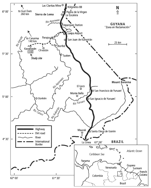
Figure 1. Gran Sabana, Venezuela. Location of study site and sites mentioned in the text.
Kavanayén is located at 5o35’N, 61o47’W (Figure 1). Average annual temperatures vary between 20 and 25oC; annual precipitation varies between 1800 and 2500mm (Kingsbury, 1999). Elevations are between 1000 and 1200m above sea level (Elcoro and Vera, 1986), with the "town" higher on the plateau and the major areas of cultivation in the valleys a few hundred meters below. The direction of the wind is generally from the East (Northeast and Southeast) to West and reaches velocities of up to 20km/h (Elcoro and Vera, 1986). Annual relative humidity is between 45 and 96%.
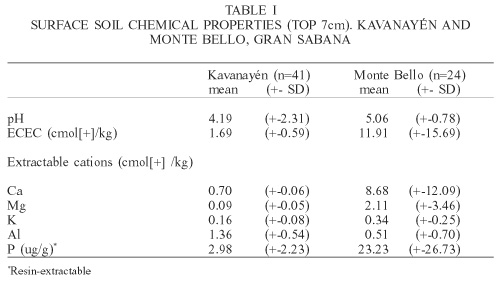
Soil fertility in the region is strongly influenced by the underlying geology. Located on a sandstone plateau, soils in the community of Kavanayén are generally very sandy and infertile (Kingsbury and Kellman, 1997). As indicated in Table I, comparisons of surface soils below undisturbed old growth forests in Kavanayén with those in the more southern Gran Sabana community of Monte Bello (see Figure 1) indicate the relative infertility of soils in the former area.
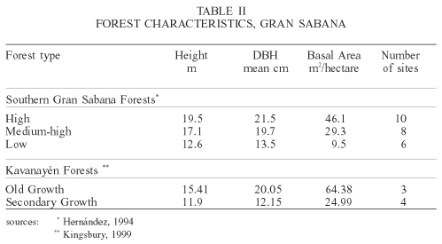
General characteristics of old and secondary growth forests in the Gran Sabana are presented in the following Table II.
High forests were defined by Hernández (1994) as those with canopy heights >18m; medium-high forests are those with canopy heights between 15 and 18m. These two forest types can be taken as synonymous with "old growth forest" as defined in this study. Low forest was defined by Hernández (1994) as forest with canopy heights <14m and can be taken as approximates to secondary growth forests in Kavanayén. Higher basal areas in old growth forests in Kavanayén as compared to those in the southern Gran Sabana may reflect sampling bias (forests surveyed in Kavanayén were adjacent to areas previously cultivated and the sample may therefore be biased in favour of more fertile sites).
Pemón Agriculture
Traditional agricultural practices
Pemón subsistence is traditionally based on shifting cultivation. Like other horticultural societies of the Orinoco Basin (Harris, 1969), Pemón agriculture is characterized by a reliance on fast-growing tubers: yuca, sweet potatoes and yams. Criollo foodstuffs are available for sale in some communities and wage workers there purchase more food than do non-wage workers. However, cultivation remains the primary means of subsistence.
Conucos are traditionally cut in the forest fragments, preferably medium-high forests (Dezzeo, 1994) adjacent to the open savanna where settlements are located. With the exception of the centuries-old introduction of steel tools, the tool inventory and labor involved in agriculture has remained remarkably similar for centuries. There have been, however, some notable changes in agricultural site selection characteristics in some Pemón communities.
Earlier studies of the Pemón stated that site selection for new conucos was "dictated exclusively on pragmatic grounds" (Urbina, 1979). Sites had to be well-drained, preferably near water and free of large quantities of surface or shallow roots which make planting difficult. Pemón also preferred to locate their settlements in flat areas of savanna, near a year-round water source, and with easy access to forests (Urbina, 1979). Once a good settlement location was found, nearby forest fragments would be used intensively until adequate amounts of preferred medium-high forest no longer remained.
The period of active cultivation (planting, weeding and harvesting) for an individual conuco varies from 2 to 3 years. Though a possible response by a shifting cultivator to declining forest resources is to extend the cultivation cycle, the length of cultivation in the Gran Sabana appears to have remained constant over more than 100 years. In the 1880s in the Roraima region, Im Thurn (1967, reprint of 1883 edition) observed that "a field is deserted after three or four crops have been taken from it; and a new clearing is then made and planted." The length of time observed between planting and harvesting was nine to 10 months (Im Thurn, 1883). Three harvests from a single conuco would then mean a period of active cultivation of 27 to 30 months at the shortest, and 36 to 40 months at the longest.
The length of fallow practiced by the Pemón varies between 5 and 15 years in the southern part of the Gran Sabana (Azuaje, 1986), to 15 years in the central part near Tuaukén (Urbina, 1979), and 12 to 26.5 years in Kavanayén in the northern part of the Gran Sabana (Elcoro and Vera, 1986). As Azuaje notes, actual fallow periods are dependent on the recuperative capacity of the forest and on land use pressure. His informants reported that a fallow was ready to be recultivated when there were no shrubs or grass and one could see clearly - there was little "tangled" vegetation in the site, in which case it was described as being "poco enmarañado" (Azuaje, 1986).
These actual fallow periods are significantly shorter than the 50 to 100 years suggested as necessary in the Gran Sabana by scientists (Elcoro and Vera, 1986; Fölster, 1986). A possible explanation for this discrepancy is that, for the Pemón, a sufficient fallow period is one where the forest has recovered to the point where it can be cut again and produce an adequate crop, while for the scientists it typically means when a secondary forest similar in structure and species composition to the primary forest has become established.
As other researchers (for example Azuaje, 1986) have found, questioning the Pemón about the length of an "appropriate" fallow period is problematic due to difficulties in translation of both words and concepts. The Pemón answer is, typically, "depende" ("it depends"). When pressed for a quantifiable response, Pemón will answer that a forest is ready to be cut again when the trees are "como un hombre" ("like a man" or "as big as a man"), meaning the diameter, as opposed to the height, of an adult man. Except on very fertile tropical soils, it requires much more than the 15 to 26.5 years (the fallow period currently practiced by the Pemón) in order for trees to attain such diameters.
During the slow process of forest re-establishment after cultivation, light-demanding herbaceous species (weeds and grasses), stump sprouts (coppice) from trees that survived the initial burn and fast-growing pioneer tree species first establish. The vegetation mix is slowly transformed as tree species form young and then old secondary forests (Nye and Greenland, 1960), asserting dominance and excluding weedy herbs. In the absence of other disturbances, such as fire, a regional forest flora gradually becomes dominant again and soil nutrient levels approach pre-disturbance levels.
In stable systems of shifting cultivation forest is not replaced by savanna during the fallow period. The factors that exert a controlling influence over forest succession after a disturbance such as cultivation include the availability of regenerating germplasm (e.g. sprouting stumps, tree seed banks), of microhabitats for plant establishment, and of nutrients for plant growth (Uhl, 1987).
Site selection characteristics and land use practices, as well as pre-existing resource endowments (i.e., forest characteristics and ecology; soil fertility), all influence these factors.
Pemón prefer to cultivate in the same areas that were previously cultivated by their family (parents and grandparents). This produces an informal type of hereditary land rights within a communal property rights system.
All land is held in common by the community. Current use (active conucos) confer exclusive land use rights for the family that cuts and cultivates the site. While it may be an individual husband-wife pair that expends the vast majority of labor in site preparation and cultivation, use rights (to the products of the conuco) also commonly extend to the couple’s parents, siblings and their children (the primary couple’s nieces and nephews). When a couple decides to cut a new conuco, they usually do so near conucos of other family members and this fits in with the mixture of rights accorded to individual couples and individual extended family groups.
These individualized rights within the community property system also extend through the fallow period, as the collection of older crops and wood for cooking fuel are also tied to the family that previously cultivated the site. Once a site is fallowed, it reverts to the community and "theoretically anyone may cultivate it when it regenerates sufficiently to sustain cultivation" (Thomas, 1982). The situation is more complex, due to the preference of relatives for maintaining fields close to each other and the practice of returning to recultivate one’s former fields.
Contemporary agricultural practices: The role of cultural change
Pemón traditionally had a very diffusely-distributed population of low local density and small settlements. In the 1970s, Thomas (1973) reported an overall density of 1 person per 4.1km2, while an earlier source reported an average of one person per 3.8km2 (Beard, 1953 in Means, 1995).
Compared with other South American indigenous peoples, it was noted that the Pemón "may be singular in their degree of dispersion" (Thomas, 1982). This can be seen as a historic adaptation to the non abundant resources. The degree of dispersion began to change during the late nineteenth and early twentieth centuries when the spread of the syncretic Hallelujah religion and other religious movements brought people together in central settlement locations for religious ceremonies (Thomas, 1973). Since the 1930s, the missionary activities of the Capuchins and the Seventh Day Adventists have resulted in the "agglomeration of populations surrounding mission sites at Santa Elena, Kavanayén, Kamarata and Uonkén" (Thomas, 1973). Similar agglomeration occurred around Adventist communities in the southern part of the Gran Sabana.
As a Capuchin mission and educational centre, the growth of Kavanayén is illustrative of the population agglomeration that occurred around all Capuchin centres. After the founding of the Mission in Kavanayén in 1942, the Capuchins encouraged Pemón in small communities around Kavanayén to send their children to the Mission's school. Religious Orders in Venezuela were officially delegated the responsibility for the formal education of indigenous people. In 1945 (three years after the founding of the Mission) there were 48 internados (children resident in the school whose parents did not live in Kavanayén). In 1995, however, their number (in this case all were girls) had fallen to 30 (Mission Records, Sta. Teresita de Kavanayén). After the establishment of the Mission school, many parents permanently moved to Kavanayén from other areas. To a lesser extent, the migration to Kavanayén continues.
In the early part of the XX century, Pemón communities were substantially smaller. In the late 1920s, Tate visited one typical Pemón community, the village of Tekwanno near Mount Roraima (see Figure 1), which consisted of "about 6 houses inhabited by a fluctuating population, varying from twenty to forty" (Tate, 1930). The traditional Pemón response to increases in localized population density was the establishment of new, smaller communities. The small and mobile nature of communities began to change in the 1960s when "national pressures and different economic opportunities began to encourage communities of several hundreds" (Colson, 1985). The largest Pemón community, Kavanayén, had an estimated average population in 1995 of approximately 925, densely concentrated around the community centre (the Capuchin Mission). In the national Indigenous Census of 1992, the community’s settlement pattern is described as "non-dispersed" (República de Venezuela, 1993, Tomo II).
Village fissioning no longer occurs also due to the attraction of services (schools, clinics, etc.) in the demarcated indigenous communities, and the restrictions on mobility imposed by the presence of non-indigenous settlements and activities (hydro-electric projects, mining operations). Pressures against village fissioning exist at a bureaucratic level as well. Only demarcated, recognized indigenous communities are entitled to government services such as school supplies and teachers, building materials and visits from medical personnel.
While communities and residences are now permanent, the nature of shifting cultivation requires that fields are non-permanent. However, given that the forests around settlements are limited, the result is that land use has necessarily become more intensive.
Following the increasing trend to sedentarism, increasing size of communities and increasing influence of factors which favor cultivation of less distant sites, the distance from primary residences to fields has become shorter - in 1995, conucos were located an average of 112.4min walk away while fallows of 5 years or more were an average of 137.23min away, for a decrease of 49.6min round-trip (Kingsbury, 1999). The centre of the community (around the Capuchin Mission) has remained unchanged since Kavanayén was founded and primary residences have always been located in this general area.
There were only 30.5% of rastrojos one hour or less away from the center of town while 34.6% of conucos were located this close to town. At two hours distance from town, the change in proximity of fields is even more marked - 43.3% of rastrojos were more than two hours walk from primary residence, while only 34.5% of conucos were located this far from the center of the community (Kingsbury, 1999). While this at first appears counter-intuitive - there is more old growth forest further from the center of the community - it reflects a change in site selection preferences over time. This change in field location then reflects a change in preference for proximity to residence over type of forest (high or low) for cultivation.
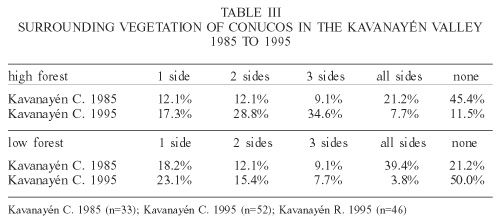
It is clear from the data in Table III that there have been changes in the surrounding vegetation types and border characteristics of fields. Data drawn from from Elcoro and Vera’s (1986) "Land Use and Vegetation Maps" which indicated the vegetation type around the conucos surveyed in 1985, is listed as "Kavanayén C. 1985" and compared to similar data from the 1995 conuco surveys done in the same areas in this study, labeled "Kavanayén C. 1995". Of the latter-most data set, only rastrojos with water or cliff borders were included. This smaller group was chosen as these types of borders –unlike true vegetation types– are not subject to changes in the fallow period. Only data from conucos in the valleys in front on the downtown area of Kavanayén, the area mapped by Elcoro and Vera in 1985, is included in Table III.
In 1985, more conucos were cut in the middle of high forest (21.2% of fields with high forest on all sides compared to 7.7% in 1995). The use of low forest has also declined dramatically.
While the practice of cutting conucos adjacent to savanna is still rare, their proximity to savanna has increased. Even assuming that some of the savanna near rastrojos is secondary grassland that established in the fallow period, a smaller percentage of rastrojos have nearby savanna than do current conucos (41.7% of rastrojos are £100m from savanna compared to 62% of conucos). The average distance to savanna has also decreased – savanna was an average of 531m from rastrojos and only 369m from conucos (Kingsbury, 1999).
In Kavanayén, notable differences in site selection and agricultural participation can also be observed between Pemón who do and do not participate in wage labor (either on a permanent or seasonal basis), with waged workers locating their conucos closer to the community center where formal employment is located (Kingsbury, 1999). Approximately 10% of the adult population engages in full-time permanent or seasonal wage labor with a smaller percentage involved in casual or part-time economic activities such as the sale of foodstuffs and the repair and sewing of clothes (Kingsbury, 1999).
Given that no extensive tracts of old growth forests remain within a 45min walk from the community center, this wage dependent site selection characteristic (distance from community center), as well as the overall preference to locate fields so that services in the community center are still accessible on a daily basis, has significant implications for the overall sustainability of the agricultural system and the maintenance of the forest cover, or alternately, the loss of forest.
Pemón Demographics. Overall and Kavanayén
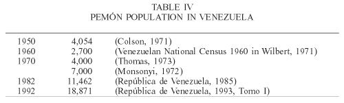
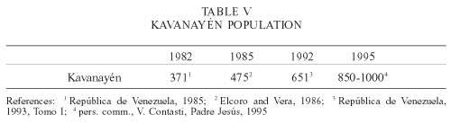
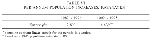
As seen in Tables IV, V and VI, population growth rates in Kavanayén, like for the overall Pemón population in Estado Bolívar, are high.
While there are clearly errors in some of the data that appears in Table IV (either the 1950 estimate was too high or the 1960 and lower 1970 estimates were too low) the Pemón population is growing rapidly, both as a result of natural population increase and immigration from neighbouring areas.
Vegetation and Land Use Changes in Kavanayén, 1985 to 1995
In 1985, Elcoro and Vera (1986) mapped the vegetation and land use in the two major areas of cultivation in Kavanayén - the east-west and north-south valleys below the cliff in front of the "downtown" area of the community. Area 1 covers approximately 2496 hectares; Area 2 covers approximately 1833ha. Using a combination of extensive aerial photography and ground surveys, these researchers distinguished among a variety of vegetation types (including several types of forests) and various land uses such as pastures, conucos and casitas. In 1995, the same areas were re-mapped in order to determine what changes in forest cover and land use had occurred in the 10-year period. Through reference to particular vegetation types in the 1985 maps, the extent of some pre-1985 deforestation can also be determined.
Land use and vegetation type mapping methods
Elcoro and Vera (1986) distinguished several vegetation types and land uses including:
- high forest (canopy height ³30m)
- medium forest (canopy height ³25m)
- low forest (canopy height <25m)
- old secondary forest rastrojo
(>15 years)
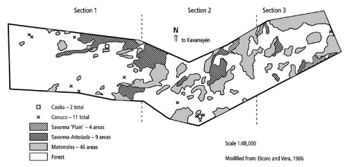
Figure 2. Kavanayén Land Use and Vegetation, Area 1, 1985.
- young secondary forest rastrojo
(<15 years)
- high matorral (a vegetation mix of small trees, shrubs, ferns and grasses with an average height of 1 to 3m)
- low matorral (<1m in height)
- edaphic matorral
- pastures
- savanna
- tree savanna (burnt tree stumps in the middle of savanna grass, or areas dominated by grass with the occasional short tree)
- bosque talado (forest cut and cleared for a conuco)
- cultivated areas (conucos)
- casitas.
Area 1 (East-West orientation) covers the valley directly in front of the "downtown", stretching from in front of the airport to the extreme west (see Figure 2), to the end of the valley (which ends in a cliff) to the east. In 1985, there was a smaller percentage of high forest in this area than in Area 2. This was interpreted as a consequence of the past intensity of use and the concentration of conucos (Elcoro and Vera, 1986).
Area 2 (North-South orientation) covers the valley west of the airport (see Figure 4). This is further from the downtown of Kavanayén and in 1985 vegetation was in the following order of descending proportion: high forest, late secondary forest, early secondary forest, high matorrales, medium-high forest, low forest, low matorrales, savanna (Elcoro and Vera, 1986).
The 1985 maps can also be analyzed for data on pre-1985 deforestation. Vegetation identified in 1985 as "Sabana Arbolada" and matorrales are definitive evidence of earlier forest displacement. In the former, the presence of trees in this type of savanna (scattered living trees or dead, burnt stumps) is evidence that the savanna is a secondary grassland. The few trees indicate that while some trees can establish in secondary grasslands, or survive from the previous forest, a vigorous secondary forest with a closed canopy cannot establish, particularly if the area is subject to frequent combustion.
After consultation with one of the authors (N. Vera, pers. comm.), the 1985 maps were redrawn to show changes in vegetation cover and land use. Dividing each of the original maps into three sections, from various points on the cliff top (1200 m.a.s.l.) overlooking the valleys a few hundred meters below, and using large areas of savanna from the 1985 maps as initial reference points, changes were sketched on top of the original maps. A visual comparison of the map size of the reference points to the actual size of the areas was used as a guide for calculating the approximate size of areas of new vegetation. After these areas were drawn onto the 1985 maps, new 1995 maps indicating changes in vegetation and land use were then produced. Areas of new secondary vegetation (plain savanna, treed savanna and matorrales) were measured using a grid overlay of squares of 1mm2 and counting the number of squares covered by each area; following the map scale, measurements were then converted to m2 and then to ha. Areas of tree savanna indicated on the 1985 maps were similarly measured.
Elcoro and Vera’s 1985 maps have been modified here to show the following, more general, vegetation types and land uses:
- primary forest (includes gallery forest, high, medium and low forests)
- secondary forest (includes old and young secondary forests)
- matorrales (all types)
- savanna (with no trees)
- tree savanna (sabana arbolada)
- conucos (active conucos and forest cut for conucos)
- casitas.
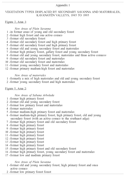
Comparisons of the 1985 maps (Figures 2 and 4) and 1995 maps (Figures 3 and 5) show the extent of deforestation and degradation of vegetation that has occurred in the 10-year period. The 1995 maps show only new areas of plain savanna, treed savanna and matorrales; vegetation types that were easily identifiable. The distinction between the two types of savanna was made following the definitions used by Elcoro and Vera (1986): "tree savanna" is grassland with burnt tree stumps or small trees and bushes in small or isolated groups; "savanna" is pure grass and other herbaceous vegetation. All the areas indicated on these maps established in what had previously been forest or a forest-matorral mix (see Appendix I for a complete list of degraded vegetation types in Areas 1 and 2). The 1995 maps show the extent of forest displacement by savanna and matorrales and the extent of degradation from a forest-matorral mix to matorral-savanna mix.
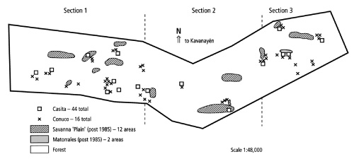
Figure 3. Kavanayén Land Use and Vegetation Changes, Area 1, 1995.
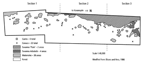
Figure 4. Kavanayén Land Use and Vegetation, Area 2, 1985.
Conucos and casitas were indicated on the map in their approximate location. Due to both topography and the height of high forest, the view of a number of casitas and conucos was likely obstructed. As well, from the cliff top, distant active conucos covered in mature yuca and other crops can often be difficult to distinguish from young secondary forest. In these cases, the vegetation was recorded as secondary forest. The numbers of casitas and conucos indicated in the 1995 maps is then likely lower than the true number.
Though numbers are then approximate due to the re-mapping methods used, particularly as a result of angles of observation, the data presented below, nonetheless, provides a picture of a degree of the extent of land use and land cover change in the areas of the most intensive and longest-standing cultivation in Kavanayén.
Changes in agricultural intensity and forest loss
Area 1:
There has been a significant increase in the amount of savanna in this valley. There is also evidence of fire intrusions into high forest (i.e. dead trees on the edges of forest fragments). On hillsides previously covered with high forest, there are now large areas of low forest, particularly in Section 3. In Section 2 there are large deforested tracts (areas of grassland) on forested hillsides.
Many of the forest fragments, particularly in Section 2, are now bordered by matorrales and scrub vegetation. In 1985 by contrast, the forest-savanna border was distinct. In Section 3, there is evidence of fire incursion into primary forest fragments (i.e. dead trees within forest fragments).
In Area 1, savanna has established in high and low forest as well as in forest-matorrale mosaics. There are 12 new areas of plain savanna covering an area of approximately 60.9ha. In 6 of these areas, old and secondary forest was displaced; in the 6 other areas, savanna has now established in what was formerly a forest-matorrale mix. Two areas of new vegetation are also associated with 1985 conucos (see Appendix I). Two new areas of matorrales cover an additional area of 2.7ha.
The number of conucos has increased four-fold from 11 to 44 conucos in Area 1. The number of casitas has also increased, from two to 16.
Area 2:
Comparisons of Area 2 in the same 10-year interval (Figures 4 and 5) show significant increase in plain savanna and a consequent reduction of forest (both primary and secondary). There are also numerous new areas of tree savanna.
In Section 1 (Southeast), savanna has extended into primary forest and has also extended into some 1985 rastrojos where secondary forest was establishing. There has also been a significant increase in matorrales in Section 1 from 1985 to 1995. In this Section there are numerous areas of matorrales and secondary forest within the primary forest fragments. There are also scattered dead trees within these fragments.
Savanna has replaced high and low matorrales in Section 2. There has also been a significant extension of 1985 savannas. These are now patches of savanna with burnt tree stumps as well as other numerous areas of treed savanna in the middle of primary forest (Section 2, East). These are perhaps rastrojos where no forest re-establishment has occurred, the burnt tree stumps having been cut and burnt for the conuco.
In 1985 in Area 2, there were five large areas of savanna Arbolada covering approximately 38ha (of a total map area of 1833ha). In 1995, there were two new areas of plain savanna covering approximately 15.23ha in areas that in 1985 were forested with primary and secondary forest; one area covers a 1985 conuco. Additionally there were 17 new areas of savanna Arbolada. These 19 new areas of both types of savanna cover an area of approximately 83.8ha.
In Area 2 the vast majority of new savannas of both types (plain savanna and savanna Arbolada) have established in what was previously forest-only (as opposed to a forest-matorrale mix). In 10 of the new areas of savanna, primary forest has been displaced; in 6 areas, savanna has displaced a combination of primary and secondary forest. In the 4 other new areas of savanna, grassland has displaced a combination of forest and matorrales (see Appendix I).
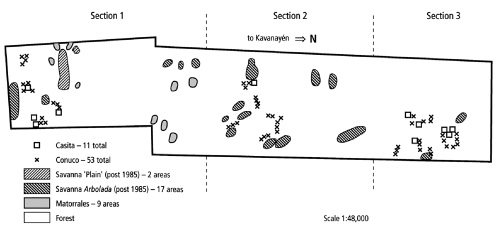
Figure 5. Kavanayén Land Use and Vegetation Changes, Area 2, 1995.
Nine small areas of new matorrales cover an additional 15.51ha. This vegetation has established in areas that were previously forested.
The number of conucos has increased over two-fold, from 22 to 53; the number of casitas has increased from zero to 11.
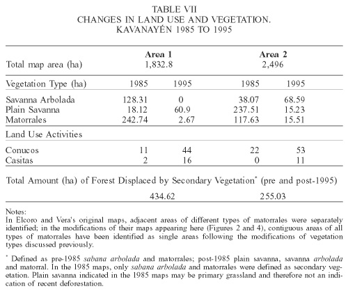
The total changes in land use and vegetation are presented in Table VII.
Discussion and Interpretation of Results
Comparison of the 1985 and 1995 maps show that:
1- Land use around Kavanayén has become much more intensive as the number and density of conucos and casitas has increased substantially; therefore, there has been substantial forest loss and displacement by savanna and matorral vegetation.
Some of the reduction in high forest is a result of the increase in the number of cultivators and conucos because, as mentioned, Pemón prefer to cut their conucos in high forest. In some cases high forest has been replaced by low forest. While this represents a potential reduction in species diversity as secondary tropical forests often have fewer tree species than do primary (high) forests, it is not deforestation. However, there has also been high forest displacement by savanna which entails both the costs of species loss as well as those of loss of forest animal habitat and the associated negative hydrological impacts.
Matorrales, like secondary forests, may be successional vegetation that, in five to ten years time may be replaced by young secondary forest. New savanna is also secondary vegetation, but is not likely transitional vegetation as it is unlikely that there will be forest re-establishment after grasses are well-established, particularly when fire events are frequent.
2- There has been a decrease in the amount of high forest. Change in edge vegetation is another, albeit minor, indication of forest loss. Forest fragments have become smaller and, in many cases, previously distinct forest-savanna boundaries have degraded and now have matorrales as intermediate vegetation between the forest and savanna. The replacement of this forest tree edge vegetation with more combustible edge vegetation may have increased the likelihood that savanna fires can penetrate the forest fragment.
3- Forest fragmentation has increased. There are numerous areas where secondary forest appears to be well-established within primary forest fragments. In the absence of fire, these areas are well-positioned to experience continued forest succession as they have nearby seed sources of forest tree species and edge microhabitats favourable to seedling establishment. In many other areas, by contrast (those areas identified in 1985 as "rastrojo bosque secundario" or "secondary forest rastrojo"), the process of forest re-establishment has been interrupted and the successional forest has degraded to savanna. In 1985, Area 1 was dominated by secondary forest (as opposed to primary forest). Ten years later much of the secondary forest has been displaced by savanna, likely due either to recultivation after an inappropriately short fallow period or intentionally lit fires that inhibited continued succession in these secondary forests.
4- The process of forest succession has been interrupted, or even truncated, in many secondary forests (identified in the 1985 maps as "rastrojos") and there has been substantial forest loss and displacement by savanna and matorrales. The increase in the number of conucos and casitas indicates agricultural intensification and change in the manner of forest use in that period. Cultivation continues to be more intensive in the area covered by Area 2 - in 1995, there were 44 conucos in Area 1 as compared to 53 in Area 2 (compared to 1985 numbers of 11 and 22 conucos respectively). As high forest is not establishing in Area 1 and secondary forest has been replaced by savanna and matorrales, conuqueros have continued their more intensive use of more distant forests in Area 2.
The density of conucos has also increased. When some of the 1995 conucos become rastrojos (fallows), fire sources (clearing fires, cooking fires, communication fires) will be closer to flammable young secondary vegetation. The potential for successful forest re-establishment may then be reduced if fire intrusion into the rastrojos occurs.
There has been significant deforestation and vegetation degradation in Kavanayén. What forest does remain is largely secondary (low) forest as opposed to primary (high) forest. In 1985, much of the high forest was in extensive (forest-only) fragments. In 1995 many of the remaining fragments were vegetation mosaics of savanna, matorrales and forest. The substantial loss of secondary forest indicates that, in many cases, forest succession has been permanently truncated. Whereas, in the past, the loss of primary forest was compensated for by the establishment of secondary forest during the fallow period, forest loss now is often permanent. The role that secondary forests play (as a future agricultural resource, as animal habitat and stabilizing the hydrological regime) has been permanently lost.
5- There are no longer any active pastures.
6- No forest has established in the 1985 savannas. Once savanna vegetation is dominant in an area, forest does not appear able to re-establish on the infertile, non-diabase soils. This is true both for tree savanna ("sabana arbolada") and the herbaceous savanna.
Conclusion
The data presented confirm that there has recently been substantial deforestation around Kavanayén. Deforestation and replacement by savanna in the Kavanayén valleys have occurred in the area in which agricultural use has been increasingly intensified since 1942 when the community was founded. Judging by the increase in the number of conucos and casitas in these valleys, agricultural use there has become even more intensive in the period from 1985 to 1995. The deforestation in these valleys is directly associated with intensive agriculture and indirectly with the increasing use of fire that accompanies cultivation.
While there is a complex relationship between environmental and cultural changes, certain features of the cultural and physical environments are clearly more important in changing the ecology of the region. Among the cultural processes, clearly the most significant has been the Pemón transition from being "migratory shifting cultivators" (Dezzeo, 1994) to sedentary cultivators who continue to shift fields but no longer shift residences and community locations and the related trend towards larger settlements. There has been a concomitant change from site selection characteristics that traditionally emphasized primarily ecological factors instead to those that now emphasize logistical factors.
When forest resources are reduced, the responses of shifting cultivators are limited primarily to abbreviation of the fallow period, locating fields more closely together, or abandoning cultivation. In the Gran Sabana, the second option in particular can result in relatively rapid environmental change and the third is generally not feasible in terms of meeting subsistence needs.
Abbreviated fallowing in Kavanayén can be inferred from the combination of deforestation and population increases and concentration. When there is pressure to stay close to town but there is little or no old growth forest close to town, a cultivator has no option but to use younger secondary forests. The presence of extensive young secondary vegetation around many of the conucos in Kavanayén and the decrease in the amount of low forest from 1985 to 1995 are evidence that fallows have shortened and that old secondary forests are not being allowed to establish.
The so-called "corridor of regeneration" (a strip of uncut high forest between fields) plays a major role in forest re-establishment after cultivation (Uhl, 1990). This corridor not only provides a nearby source of seeds for forest tree species and edge microhabitats suitable for tree seedling establishment, but importantly in the Gran Sabana where fire is a significant factor in forest re-establishment, they also provide a type of fire break, protecting fallows from fire incursion.
Analysis of the significance of various site characteristics on rates of forest re-establishment after cultivation (slope, soil fertility, root mat depth, distance to water and distance to savanna), shows that the only factor which is statistically significant is distance to savanna (Kingsbury, 1999). This significant site characteristic can more accurately be interpreted as the distance to sites of high combustibility and frequent combustion. As well, nearby savanna is also a source of easily wind-dispersed grass seeds.
It is also important to note that once matorral or savanna vegetation is well-established, the likelihood of forest re-establishment is low. On non-diabase soils in particular, soil impoverishment as a result of savanna displacement of forest (Kingsbury, 1999) and fire frequency in non-forest vegetation likely play a major role in precluding forest re-establishment in these areas.
Similar processes of environmental and cultural change are likely occurring elsewhere in the Gran Sabana in other Pemón communities, and indeed among other indigenous shifting cultivators in South America who are also experiencing a process of rapid acculturation and incorporation into non-indigenous societies and the accompanying land use changes.
While the impacts of this combination of resource reduction and increases in resource use will vary depend on the characteristics of the particular physical environment and the regional fire ecology, in certain areas (e.g., Kavanayén) where soils are generally infertile, forests have a low resilience to disturbance and slow rates of re-growth, the environmental impacts of intensified shifting cultivation (and the concomitant increases in cultivators, cultivated areas, in combustion frequencies and more combustible secondary vegetation) are both visible and negative.
While the social and micro-economic impacts of deforestation on the Pemón have not been documented, it is reasonable to conclude that these impacts will be (or in some communities, are already) also negative, likely resulting in an increased consumption of and dependency on food imported into indigenous communities, and dependency on wage labor to acquire resources with which to purchase foodstuffs. However, infrastructural weaknesses in both the transportation and employment sectors suggest that this subsequent cultural and economic change may be problematic.
This latter "data gap" on the social and micro-economic impacts of deforestation and the policy implications of increased dependency on non-agricultural labor for subsistence calls for further attention and study, and further participation of the Pemón in the management of their forest resources.
In terms of watershed and forest management, the rate of deforestation around other larger, growing and permanent communities is another important, and missing, set of data. Such data can, however, be produced in a number of ways – interviews on indigenous environmental perception, forest surveys and time series analysis of remotely sensed images.
While the process of deforestation in the Gran Sabana may be understood (even appearing obvious to some, that is, that cultural and demographic change are resulting in deforestation) the pattern of this change and the variations in this pattern at the regional, inter- and intra-community levels is not so well understood and calls for further study in order to prevent further deforestation and its negative hydrologic and cultural impacts.
ACKNOWLEDGMENTS
Logistical support for this study was provided by the Departamento de Conservación de Cuencas of Electrificación del Caroní" (EDELCA). The author thanks Alexandre Barreto, Eduardo Gómez and Yoni Rivas at EDELCA; Venancio Sucre, who provided expert field assistance in Kavanayén; Nelda Dezzeo and Judith Rosales, who assisted during the research period. Fieldwork was undertaken with the financial support of the International Development Research Centre (Ottawa, Canada) and from a National Science and Engineering Research Council of Canada grant to Professor Martin Kellman of York University (Toronto, Canada).
REFERENCES
1. Azuaje A (1986) Caracterización de Conucos en la Cuenca Alta del Río Caroní. Electrificación del Caroní. División de Cuencas e Hidrología. Yuraní, Gran Sabana, Venezuela. [ Links ]
2. Butt-Colson A (1971) Comparative Studies of the Social Structure of Guiana Indians and the Problems of Acculturation. In Salano FM (Ed) The Ongoing Evolution of Latin American Populations. Charles C. Thomas. Springfield, Ill. pp. 61-126. [ Links ]
3. Butt-Colson A (1985) Routes of knowledge: an aspect of regional integration in the circum-Roraima area of the Guiana Highlands. Antropologia 63-64: 103-149. [ Links ]
4. Dezzeo N (1994) Ecology of the Gran Sabana Uplands (Venezuelan Guayana). Scientia Guaianae No. 4: xv-xxxviii. [ Links ]
5. Elcoro S, Vera N (1986) Estudio de Rastrojos en Areas con Altas Concentraciones de Población en Kavanayén, La Gran Sabana, Estado Bolívar. B.Sc. Thesis (Forestry Sciences). Universidad de los Andes, Mérida, Venezuela. [ Links ]
6. Fölster H (1986) Forest-Savana Dynamics and Desertification Processes in the Gran Sabana. Interciencia 11: 311-316. [ Links ]
7. Fölster H (1995) Local Population Concentrations in the Venezuelan Guayana and the Breakdown of Traditional Swidden Agriculture. Scientia Guaianae No. 5: 65-78. [ Links ]
8. Harris DR (1969) Agricultural systems, ecosystems and the origins of agriculture. In Ucko PJ, Dimbleby GW (Eds) The domestication and exploitation of plants and animals. Gerald Duckworth & Co. London. pp. 3-16. [ Links ]
9. Hernández L (1994) Bosques. In Ecología de la Altiplanicie de la Gran Sabana (Guayana Venezolana) I. Scientia Guaianae No. 4: 80-94. [ Links ]
10. Im Thurn EF (1967) Among the Indians of Guiana; Being Sketches Chiefly Anthropologic from the Interior of British Guiana. Dover Publications. New York. Reproduction of the 1883 edition. [ Links ]
11. Kingsbury ND (1999) Increasing Use of Decreasing Resources: A Case Study of Pemón Amerindian Shifting Cultivation, Gran Sabana, Venezuela. Ph.D. dissertation. York University, Toronto, Canada.
12. Kingsbury N, Kellman M (1997) Root Mat Depths and Surface Soil Chemistry in Southeastern Venezuela. J. Tropical Ecology. 475-479. [ Links ]
13. Means DB (1995) Fire Ecology of the Guyana Region, Northeastern South America. In Fire in Wetlands: A Management Perspective. Proceedings of the Tall Timbers Fire Ecology Conference No. 19. Tall Timbers Research Station. Tallahassee, Florida. pp. 61-77. [ Links ]
14. Miranda M with Blanco-Uribe A, Hernández L et al. (1998) All That Glitters is not Gold: Balancing Conservation and Development in Venezuela’s Frontier Forests. World Resources Institute. Washington, D.C. [ Links ]
15. Monsonyi E (1972) Indian Groups in Venezuela. In The Situation of the Indian in South America. World Council of Churches. Geneva. pp. 388-391. [ Links ]
16. Morales L, Gorzula S (1986) The Interrelations of the Caroní River Basin Ecosystems and Hydroelectric Power Projects. Interciencia 11: 272-277. [ Links ]
17. Nye PH, Greenland DJ (1960) The Soil Under Shifting Cultivation. Commonwealth Agricultural Bureau. Bucks, England. [ Links ]
18. República de Venezuela (1985) Censo Indígena de Venezuela, 1982 - Nomenclador de Comunidades y Colectividades. Oficina Central de Estadística e Informática Nº 180. Caracas. [ Links ]
19. República de Venezuela (1993) Censo Indígena de Venezuela, 1992. Oficina Central de Estadística e Informática. Caracas. Tomo I & II. [ Links ]
20. Tate GHH (1930) Notes on the Mount Roraima Region. Geographical Rev. 20: 53-68. [ Links ]
21. Thomas DJ (1973) Pemon Demography, Kinship, and Trade. Ph.D. dissertation. University of Michigan. [ Links ]
22. Thomas DJ (1982) Order without Government: Pemon Indian Society. University of Illinois Press. Chicago. [ Links ]
23. Uhl C (1987) Factors Controlling Succession Following Slash-and-Burn Agriculture in Amazonia. J. Ecology. 75: 377-407. [ Links ]
24. Uhl C (1990) Deforestation, Fire Susceptibility, and Potential Tree Responses to Fire in the Eastern Amazon. Ecology 7: 437-449. [ Links ]
25. Urbina L (1979) Adaptación Ecológico-Cultural de los Pemón-Arekuna: El Caso de Tuaukén. M.Sc. dissertation. Instituto Venezolano de Investigaciones Científicas. Caracas. [ Links ]
26. Wilbert J (1971) Cultural Variability in Venezuelan Indian Tribes. In Salano FM (Ed.) The Ongoing Evolution of Latin American Populations. Charles C. Thomas. Springfield, Ill. pp. 127-159. [ Links ]
