


Services on Demand
Journal
Article
 Article in xml format
 Article references
 Send this article by e-mail
Indicators
-
 Cited by SciELO
 -
 Access statistics
Related links
-
 Similars in
SciELO
Similars in
SciELO
Share

 Permalink
Revista de la Facultad de Ingeniería Universidad Central de Venezuela
Print version ISSN 0798-4065
Rev. Fac. Ing. UCV vol.20 no.4 Caracas Oct. 2005
Recent seismicity in Northeastern Venezuela and tectonic implications
MONIKA SOBIESIAK1,2, LEONARDO ALVARADO1, RAQUEL VÁSQUEZ1
1 Fundación Venezolana de Investigaciones Sismológicas (FUNVISIS), Prolongación Calle Mara, El Llanito, 1070
Caracas, Venezuela, e-mails: lalvarado@funvisis.gob.ve; rvasquez@funvisis.gob.ve
2Now at GeoForschungsZentrum Potsdam, Germany, e-mail: polar@gfz-potsdam.de
RESUMEN
En este trabajo se presentan los resultados de los estudios de la actividad sísmica reciente en el noreste de Venezuela y el sureste del Caribe (9º - 13.5º N y 59º - 65º O). Se pudo obtener un mapa preciso y detallado de los hipocentros por la re localización de los eventos existentes y por el despliegue de instrumentos de banda ancha en la región a finales del año 2000. Se identificó una zona con ausencia de hipocentros alrededor de los 40 km que separa la sismicidad superficial perteneciente a la ambiente transcurrente de la sismicidad perteneciente a la zona de subducción. Además se pudo observar una estructura en forma de columna en la zona de subducción. De los resultados de los estudios estadísticos se supone la existencia de interacciones entre los dos regímenes tectónicos así como cambios en los campos de esfuerzos locales y regionales de ambos ambientes por interacción cruzada de los eventos sísmicos
Palabras claves: Sismicidad, Interacción régimen transcurrente y régimen de subducción, región oriental de Venezuela.
RECENT SEISMICITY IN NORTHEASTERN VENEZUELA AND TECTONIC IMPLICATIONS
ABSTRACT
In this study we present results from the investigation of recent seismic activity in northeastern Venezuela and the southeastern Caribbean (9o - 13.5o N and 59o – 65o W). We were able to map precise and detailed hypocenters by relocating existing data sets and because of the deployment of broad band instruments in this region beginning at the end of 2000. We identify a hypocentral gap at about 40 km depth between shallow seismicity belonging to the strike slip environment and the seismicity of the subduction environment. Furthermore, we map a column-like hypocentral structure in the subduction area. From results of statistical studies we hypothezize interactions between the two tectonic regimes such as changes in the actual local and regional stress fields of both environments by cross triggering of seismic events.
Key words: seismicity, interactions of transcurrent and subduction regime, oriental region of Venezuela.
Recibido: mayo de 2003 Recibido en forma final revisado: diciembre de 2005
1. INTRODUCTION
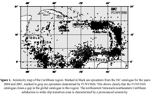
A seismicity map shows that northeastern Venezuela and the adjacent southeastern Caribbean have the highest
seismicity rate in Venezuela in recent years (Figure 1). In addition, historic records for this region show that medium sized events with varying recurrence times (Audemard, 1999a) have also occurred. For example a large earthquake in 1766 was attributed by several authors to motion on the El Pilar right lateral strike slip fault (Fiedler, 1961, Kelleher et.al., 1973, Grases, 1979); more recent investigation associates this event with subduction offshore and north of eastern Venezuela (Audemard, 1999a). In this paper we assess the relative contributions of these two principle active tectonic regimes.
The El Pilar and Los Bajos-El Soldado fault zones which show micro and intermediate to large scale seismic activity in recent years. Beltran and Giraldo (1989) determined that transcurrent motion is taken up in a coastal strip of major east-west trending faults in northeastern Venezuela. The El Pilar fault constitutes the southern boundary of this zone. Further east, into the Gulf of Paria, the NW-SE trending Los Bajos and El Soldado are seismically active and take up present day right lateral strike slip motion (Beltrán and Giraldo, 1989, Perez and Aggarwal, 1981, Russo et.al., 1993). This motion is probably transfered to the NE-trending Central Range fault in Trinidad (Weber et.al., 2001).
Beneath and north of the Paria Peninsula (Russo et. al., 1993; this study) an intermediate-deep hypocentral cluster defines
a segment of the subduction zone which is associated with the Lesser Antilles island arc (Wadge and Shepherd, 1984). We also investigate the contact zone between the subduction environment which exhibits intermediate depth seismicity and the transcurrent environment showing shallow seismicity, i.e. the subduction to strike slip transition zone characterizing the observed seismicity pattern in northeastern Venezuela. The main objectives of this study are to present new insight in seismotectonic structures using precisely determined earthquake hypocenters, a well constrained focal mechanism solution for a 2002 subduction event and to speculate on
possible interactions between the transcurrent and subduction regimes.
2. DATA
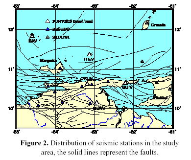
Figure 2, shows the station distribution in the study area. These stations belong to various networks which monitor the seismicity in the region: the broad band National Seismological Network of Venezuela (FUNVISIS), the short period, one component network of the East (RESUDO, Seismological Center of UDO) and the Seismological
Network of Trinidad and Tobago (Seismic Research Unit of the University of West Indies: SRUUWI). The dataset we use in this study was extracted from the FUNVISIS catalogue. Hypocenters were determined using real time data at FUNVISIS. Additional P and S phase readings from RESUDO and SRUUWI were included in hypocenter calculations when available.
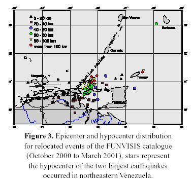
After deployment of the first broad band station on Paria Peninsula (Figure 2) a clear improvement of completeness, magnitude threshold and precision of hypocenter determination for the regional catalogue was obtained. Figure 3 shows the level of precision obtained.
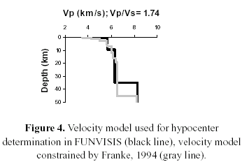
The velocity model used for recent hypocenter determination in our routine analysis is shown in Figure 4 (FUNVISIS 1988). It is a fairly simple model and is used for all location calculations in Venezuela. Thus it does not account for the very complex tectonic structure we wish to study in northeastern Venezuela. Nevertheless our calculated hypocenters show reasonable internal accuracy according to the tests using SEISAN (Havskov & Ottemoeller, 1999). Two attempts have been made to gain more detailed velocity models including tomography studies of regional seismicity (Franke, 1994) and aftershock seismicity (Grosser et.al., 2001). The velocity model of Franke (1994) derived shows a fine structured homogeneous layered model. The results of Grosser et. al. (2001) show strong vertical inhomogeneities including up to 20% difference in seismic velocity north and south of the El Pilar fault. This result could be complicated considering that the subduction zone north of Paria could cause strong arrival time differences for all stations in the area. These arrival time differences were observed in our data and will be explained in detail in a later section.
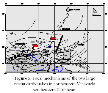
3. LARGE EVENTS
In recent years two large earthquakes occurred northeastern Venezuela and southeastern Caribbean
5): 1) the Mw=6.9 shock of July 1997, with its hypocenter near Cariaco (Romero et.al., 1999, Audemard, 1999b)
2) the Mw=6.0 subduction event of October 4, 2000, of Paria Peninsula.
event reflects the transcurrent regime of the El Pilar zone showing a strike-slip focal mechanism. The
segment of the rupture plane dip slightly to the according to aftershock investigations (Baumbach 2004).
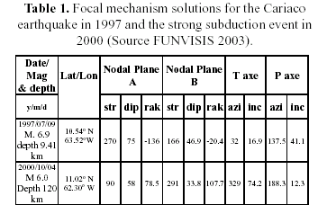
The 2000 earthquake is likely subduction-related according to its depth of ~ 120 km. A focal mechanism for this was calculated with P wave first arrival polaritis real time data of FUNVISIS. This analysis gives type mechanism with the pressure axis pointing about E (Figure 5). Our solution is confirmed by the result using global seismic data. See Table 1 for source parameters of the two events and Figure 6 for their locations. Investigations of historical records have shown regimes are capable of producing large earthquakes (Audemard, 1999b, Russo et.al., 1992).
4. SPATIAL AND TEMPORAL DISTRIBUTION OF SEISMICITY
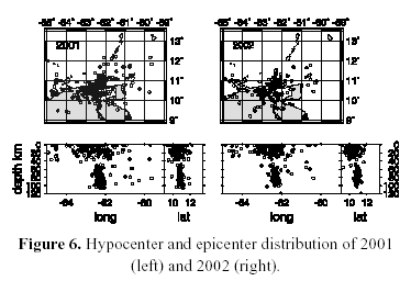
In Figures 6a and 6b which show the epicenter and hypocenter distribution in the NE Venezuela transcurrent to
subduction transition region for the year 2001 and 2002. Shallow events presumably related to transcurrent motion are concentrated on the eastern half of the El Pilar fault system, and the faults of Los Bajos and El Soldado. Figure 6 includes an earthquake swarm of about 80 events that occurred south of the city of Carupano in April 2001. This swarm can be seen also in Figure 3 marked as a cluster of triangles south of Carúpano. In Figure 6a it can be identified in the east-west depth section within the shallow events as a pronounced vertically elongated cluster at approximately 63.3 W.
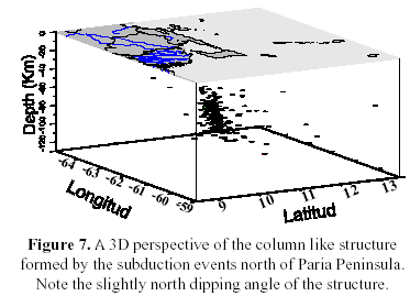
The deeper events in 2001 and 2002 can be seen in the eastwest depth sections as a concentration of hypocenters between 62 and 63 W (Figures 6a, 6b). The north-south depth sections show a concentration around 11 N and a slight dip of the elongated cluster to the north. For a better view of this high activity zone we plot a 3D view in Figure 7. The view angle here clearly shows column-like and subvertical structure of this seismic zone.
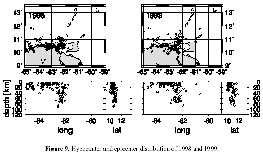
A very striking feature in all depth sections (Figure 6a and 6b) for 2001 and 2002 is the lack of seismicity at around 40 km depth. This is most obvious for the 2001 and 2002 time spans, but can also be seen in the 2000 hypocenter distribution (see Figure 8). It is interesting to note here, that the hypocenter distribution in 1998 and 1999 does not show this gap around 40 km depth (figures 9a & 9b). A plausible reason for this could be the lesser accuracy in hypocenter determination before the deployment of broad band instruments in this region. Being more speculative, it could also be due to a stress transition triggered by the 1997 shallow earthquake causing additional seismicity where the gap later on reappears.
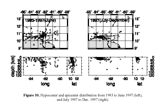
If we go back in time and examine the development of seismic activity starting in 1993 there are several interesting phenomenas to observe. From 1993 to June 1997, just before the large shock of Cariaco, a rather diffuse epicentralhypocentral distribution is seen (Figures 10 a). Despite its nature, the subvertical subduction zone can be recognized. From July to December 1997 seismic activity concentratedon the rupture zone of the Cariaco earthquake and slab events were rare to absent (Figure 10 b). Plots from 1998 and 1999 show a similar picture (Figures 9a & b). Activity remained high on the rupture zone of the Cariaco earthquake (Figure 9a), but deep slab seismicity is also well expressed.
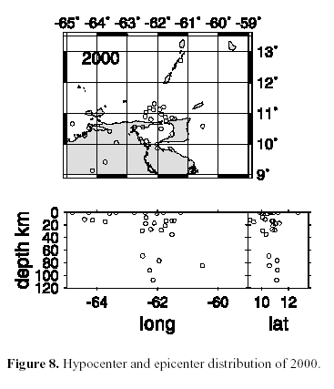
In 2000, there seems to have been generally less seismicity in both the slab and strike slip regimes (Figure 8).
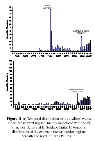
To gain a better understanding of the development of seismicity in time, we show the histograms for the number
of shallow (Figure 11a) and deep events (Figure 11b) from 1993 - 2002. The obvious apparent increase in number of events from 2001 onwards occurred in both regimes, and can be attributed to the implementation of the broad band network. In addition a swarm activity occurred in the transcurrent regime in April 2001 (Figure 11a).Notwithstanding the April 2001 swarm, the background level of seismicity shows approximately the same rate. Before 2001, there were more shallow events related to the 1997 Cariaco earthquake and its aftershock sequence. 2000 appears in both histograms as a period of reduced seismicity, except for the peak in October 2000 representing the aftershocks of the Mw=6.0 subduction event.
5. b-value STUDY
b-value studies in seismically active areas have gained significant importance in recent years as the improvement
of seismological instrumentation has led to lower magnitude threshold detection and thus to more complete seismological catalogues. From these recent investigations we learned that the b-value can vary significantly on very small local scales (within view kilometers). The spatial distribution of the bvalue can represent changes in material properties, structural unconformities and changes in the ambient stress field. This should have a strong influence on hazard assessment and seismic risk evaluations as the b-value is a key parameter in these studies.
The b-value is a constant in the relation between the frequency of occurrence and magnitude of earthquakes in
the Gutenberg-Richter frequency-magnitude distribution (Gutenberg and Richter, 1944, Ishimoto and Iida, 1939):
![]()
Static and dynamic changes of b in an area of densely distributed hypocenters are associated with changes in
material properties (Mogi, 1962) or changes in the stress field (Scholz, 1968). Various high resolution b-value
investigations were used to find magma chambers beneath volcanoes (Wiemer and McNutt, 1997), asperities in active fault zones (Wiemer et.al., 1998, Wiemer and Wyss, 1997), and static and dynamic stress changes in aftershock sequences related to main shock rupture processes (Sobiesiak, 2000, Baumbach et.al., 2004).
5.1 Method and results
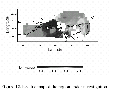
In this study we mapped b-values using the ZMAP software of Wiemer and Zuñiga (1994) of both strike slip and
subduction events using the catalogue of FUNVISIS from 1923 to 2001. 1400 events and a grid cell size of 10 x 10 km were used in the calculations. A b-value was calculated with a maximum likelihood method at each grid node using the 100 nearest events. Our resulting b-value map is shown in Figure 12. The bvalues
are clearly spatially variable. We resolve low bvalues along the western part of the El Pilar fault, particularly
in the vicinity of the 1997 Cariaco earthquake (marked by a white star in Figure 12) and the coastal and marine area north of this segment. Further east the number of events was not sufficient to calculate a b-value. The Gulf of Paria, Trinidad and the subduction environment offshore Paria Peninsula and Trinidad are characterized by higher b-values ranging between 0.8 and 1.0. Low b-values are located along the coast west of the town of Carupano, around the El Pilar fault and towards the Orinoco delta. The lowest b-values are observed along the coast near Carúpano.
6. RESIDUALS OF PHASE ARRIVAL TIMES
In seismological routine data analysis time residuals of Pand S wave arrivals are calculated for each station site. These time residuals (rms) show the differences between expected arrivals for P and S phases according to the input velocity model and actual arrival times in the seismograms. Thus the rms can be used as an error estimation for phase arrivals. The errors can include source effects, deviations of the inpu velocity model from the real velocity structure along the ray paths, local inhomogeneities and soil effects at the station sites. In case the seismic ray travelling from source to receiver passes a homogeneously layered medium, the rms
distribution at a station site should be Gaussian. Any deviation of the rms from a Gaussian distribution can be
attributed either to instrumental problems, inadequate input velocity models or to pronounced inhomogeneities in the ray path.
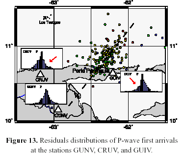
In our P wave arrival time data we observe such a deviation of the rms from Gaussian distribution for the broad band station sites CRUV and GUIV (Figure 13). While the rms of CRUV experience a shift towards later P-wave arrivals, the rms at GUIV experience a shift towards earlier arrivals (see Figure 13, observation is marked by arrows in rms histograms). Assuming that most of the seismic energy arriving at these stations is coming from deep subduction events, the P-waves arriving at CRUV were delayed on their way from source to receiver, the P-waves arriving at GUIV were accelerated. us suspect that we are dealing with a classical type of subduction in this transition area north of Paria Peninsula.
Usually thrust type events can be found in the seismogenic zone between 10 to 60 km depth where the downgoing slab is strongly coupled with the overriding crust. Elsewhere in the Benioff zone this level of coupling is much less. For example depths > 100 km normal fault mechanisms usually dominate because of the gravitational slab pull force. That makes us suppose another stress field situation is acting in our case.
Our observations and the proposed detachment of the slab (see also next section) let us hypothesize that we are dealing here with a vertical fragment of the slab which gets pushed against continental SA producing deep thrust events. Therefore we hypothesize that the proposed pushing force which thrusts the slab fragment against continental SA might be provoked by a more general NS directed compressive regime. This could be caused by relative plate motion between SA and Africa as Silver et.al. (1998) found a direction of the differential velocity vector of this plate configuration acting on the Caribbean plate which is in good agreement with the orientation of the thrust event. Additional deep thrust events in this area were reported by Tomblin (1975), Russo et.al.(1993) and Choy et.al. (1998) but with inconsistently oriented P and T axes. On the other hand results of the stressfield inversion by Choy et.al. (1998), using conventionally determined fault plane solutions and the inversion method by Angelier et. al. (1990), gives a homogeneously distributed tensional situation for the
subduction environment beneath Trinidad and further north. The authors report a compressional situation around Paria Peninsula, where the activated slab segment we image is situated.
7.2 Seismicity distribution
According to epicentral and hypocentral seismicity pattern described in section 4. we conclude that in the subduction environment we image is a vertical detached slab segment whose origin is the subduction of South American oceanic crust descending beneath the Caribbean plate. From the pattern of this well detected cluster of intermediate to deep seismicity we infer that the slab fragment has a northeasterly orientation and that at its southern edge it is penetrating into South American continental lithosphere beneath Paria Peninsula. A similar slab geometry has been suggested also by Van Decar et.al.(2003) using traveltime inversion methods. However we cannot support with our data a penetration of the segment much further to the south than 10.4 N.
We identify the upper limit of the slab fragment at ~ 40 km depth where we observe a gap of seismicity which we interpret as the separation distance between the subduction and the shallow seismicity of the transcurrent environment. This model is similar to Jácome et.al. (2003) tectonic models for the Maturin Basin showing that the sediment distribution of the Maturín Basin can be reasonably modeled using a vertical subduction zone extending downward from a depth of 40 km. In addition, Van Decar et.al. (2003) suggest a top of the high velocity structure they image to lye between poorly constrained depths of 50 and 150 km.
The dynamic nature of the seismicity pattern in the region is shown in Figures 6 to 9. The two time intervals observed of reduced seismicity are in 1993 to June 1997, before the large Cariaco earthquake in the transcurrent environment, and in 2000 before the Mw=6.0 subduction event. Whether or not these intervals of reduced seismicity can be interpreted in terms of real quiescense has to be verified in future investigations.
The similar periodicity of seismic activity can be seen in the histograms for both the transcurrent and subduction
regime (Figure 11a & b). This cause us to consider that both regimes can interact by stress transfer and crosstriggering of earthquakes. Some tie is also suggested by the timing of large events in both regimes. After the large 1997 Cariaco earthquake in the transcurrent regime, the large 2000 subduction event occured. The 2000 subduction event again was followed by shallow swarm activity. It is possible that deep events triggered shallow events (and vice versa) or that both regimes experience some of the same driving forces.
The apparent increase in background seismicity in both environments documented in the histograms after the
beginning of 2001 can clearly be attributed to the installation of broad band stations, we record the same increase in seismicity for both regions.
7.3 b-value study
Instrumentation and parameter calculations have undergone dramatic changes throughout the time interval explored in this study. We consider our results preliminary and rather speculative. Nevertheless low b-values (b < 0.4) around Cariaco might indicate accumulated stress which was not released during the 1997 rupture of the Cariaco mainshock (Figure 12).
The higher b-values further to the east and to the north (Trinidad and subduction environment) suggest a more
relaxed stress situation. This might be related to a still highlyfractured volume, caused by a large earthquake in this region.
We hypothesize that the large 1766 earthquake, which is now discussed to have been located in the subduction area, could have been capable of generating such a destructive energy.
7.4 Residuals of phase arrival times
As explained in section 6, the rms of the broad band stations CRUV and GUIV show significant deviations from a
Gaussian distribution. Searching for a cause of this deviation, we hypothesize that the delayed P phases arriving at CRUV are travelling through a less consolidated structure than the accelerated phases arriving at GUIV.
We propose that the subvertical slab fragment north and underneath Paria Peninsula could be an inhomogeneity
which might produce the observed anisotropy. This is supported by the relativ position of the two stations to the vertical fragment. As CRUV lies west of the fragment, the arriving phases could have travelled through the
unconsolidated sedimentary part of the slab fragment. On the other hand, the accelerated phases arriving at GUIV, which is located east of the fragment, then travelled through the consolidated magmatic part of the slab fragment. Weber (1990) suggested a strong influence of subduction zones on traveltimes and amplitudes of P-waves producing velocity anomalies, resulting in a pattern of alternating pronounced arrivals and shadow zones, where seismic energy is almost missing. This alternation of focusing and defocusing of radiated seismic energy is also in good agreement with the isoseismal map for the 2000 subduction event (Lotuffo and Molina, 2003), which shows two zones of high intensities (focusing) divided by a shadow zone of relatively low intensities (defocusing).
8. CONCLUSION AND OUTLOOK
Distribution of phase arrival time residuals and tomography studies (Grosser et.al., 2001) let us suppose that there is a strong influence of the complex tectonic structure of the region on seismicity patterns. These must be taken into account and have to be corrected for in routine analysis of seismicity.
However, actual hypocenter determination seems to be precise enough for us to postulate a lack of seismicity around 40 km depth. We associate this gap with the distance between the shallow seismicity of the strike slip environment and the activity of the subduction area, which is supported by results of tectonic modeling by Jacome et.al. (2003).The column-like feature constrained from intermediate to deep seismicity in the subduction zone is proposed to be a discontinuous or detached piece of slab. According to these observations we can classify the subduction to strike-slip transition zone of northeastern Venezuela/southeastern Caribbean as an open corner type transition (Mann and Frohlich, 1999).
For future improvement, we suggest that full seismogram inversion of broad band data be used to derive more precise focal mechanism solutions. These should lead to a better understanding of very local and regional stress fields and heir interactions, which might link larger earthquakes in the transcurrent and the subduction environments.
Furthermore, we suggest that developing a routine analysis of the seismicity which considers inhomogeneities like
vertical features of strong velocity contrasts as slab like structures or different crust types could be achieved by means of ray tracing methods and would lead to more precise mapping of seismotectonic structures.
Dynamic changes in seismicity patterns and behavior of seismic clustering in time should also be investigated by
means of b-value, Coulomb-stress, stress drop etc. monitoring which should make valuable contributions to
seismic hazard assessment in the area. A first step to this end would be to evaluate all existing sub-catalogues for this region and, if possible, also doing a joined hypocenter determination.
ACKNOWLEDGEMENTS
The authors would like to express their thanks to John Weber and Carlos Mendoza for their detailed reviews which helped to improve this paper substantially. Contribution presented at the III Coloquio sobre Microzonificación Sísmica in Caracas in 2002.
REFERENCES
1. ANGELIER, J., TARANTOLA, A., VALETTE, B., MANOUSSIS, S., 1982. Inversion of field data in fault tectonics to obtain the regional stress; I, Single phase fault populations; a new method of computing the stress tensor. Geophys. J. R. Astron. Soc., 69, (3); 607-621. [ Links ]
2. AUDEMARD, F., 1999a. Nueva percepción de la sismicidad histórica del segmento en tierra de la falla El Pilar,
Venezuela nororiental, a partir de primeros resultados paleosísmicos, VI Cong. Venez. de Sismología e Ing.
Sísmica, Mérida, extended abstract, CD format 10 pp.
3. AUDEMARD, F., 1999b El sismo de Cariaco del 9 de Julio 1997. Edo. Sucre, Venezuela: Nucleación y propagación
de la ruptura a partir de observaciones geológicas, VI Cong. Venez. de Sismología e Ing. Sísmica, Mérida,
extended abstract, CD Format, 19 pp.
4. BAUMBACH, M., H. GROSSER, G. ROMERO, J. ROJAS, M. SOBIESIAK, W. WELLE, 2004. Aftershock Pattern of the
July 9, 1997 Mw=6.9 Cariaco Earthquake in Northeastern Venezuela, Tectonophysics, 379, 1-23.
5. BELTRÁN, C., AND C. GIRALDO, 1989. Aspectos neotectónicos de la región nororiental de Venezuela, Memorias VII Cong. Geol. Venez., Barquisimeto, Tomo III, 999-1021 [ Links ]
6. CHOY, J.E., M.T. MORANDI, C. PALME DE OSECHAS, 1998. Determinación de patrones de esfuerzos tectónicos para el Oriente de Venezuela - Sureste del Caribe a partir de mecanismos focales, Memorias del IX Cong. Venez. de Geofísica, (Caracas). CD Format, 8p. [ Links ]
7. FIEDLER, G., 1961. Áreas afectadas por terremotos en Venezuela, Memorias del III Congreso Geol. Venez., vol.
IV, (Caracas), 1791 – 1810.
8. FRANKE, M., 1994. Seismotektonik und seismische Gefährdung in Nordost-Venezuela abgeleitet aus
mikroseismischen Messungen. Berichte aus dem Zentrum für Meeres- und Klimaforschung (Institut für
Geophysik, Hamburg, Germany), C (3), 100 pp.
9. FUNVISIS, 1988. Boletín Sismológico de Venezuela, Vol 5 No 1, 40 pp. [ Links ]
10. FUNVISIS, 2003. Mapa compilación de soluciones focales para sismos sentidos en Venezuela y áreas vecinas. [ Links ]
11. GRASES, J., 1979. Investigación sobre los sismos que han afectado el oriente de Venezuela, Delta del Orinoco y
regiones adyacentes, Informe Intevep S.A., 107 pp.
12. GROSSER, H., A. RIETBROCK, M. BAUMBACH, G. ROMEROTORRES, J. ROJAS, 2001. Seismic Tomography in the
Aftershock Region of the Cariaco Earthquake 1997, EOS Trans., AGU, 82(47), Fall Meet. Suppl., Abstract S32E-
03.
13. GUTENBERG, R., AND C.F. RICHTER, 1944. Frequency of Earthquakes in California, Bull. Seism. Soc. Am., 34,
185 – 188.
14. HAVSKOV, J. AND L. OTTEMOELLER, 1999. Electronic Seismologist - SEISAN Earthquake Analysis Software,
Seism. Res. Lett., 70, 532 – 534.
15. ISHIMOTO, M. AND K. IIDA, 1939. Observation of earthquakes registered with the microseismograph constructed
recently, Bull. Earthquake Res. Inst., (Univ. Tokyo), 17, 443 – 478.
16. JACOME, M.I., N. KUSZNIR, F. AUDEMARD, S. FLINT, 2003. The Formation of the Maturin Foreland Basin, Eastern Venezuela: Thrust Sheet Loading or Subduction Dynamic Topography, Tectonics, 22, N (5), 1-17. [ Links ]
17. KELLEHER, J., L. SYKES, J. OLIVER, 1973. Possible Criteria for Predicting Earthquake Locations and Their
Application to Major Plate Boundaries of the Pacific and the Caribbean, J. Geophys. Res., 78(14), 2547 –
2585.
18. LOTUFFO, M., MOLINA, A., 2003. Evaluación macrosísmica y mapa preliminar de isosistas correspondiente al sismo
del 4 de octubre de 2000 Guiria, Estado Sucre, VII Congreso Venezolano de Sismología e Ingeniería
Sísmica, abstract.
19. MANN, P. AND C. FROHLICH, 1999. Classification and tectonic comparison of subduction to strike slip transitions on active plate boundaries, Penrose Conference, (Puerto Plata ),extended abstract, 3 pp. [ Links ]
20. , K., 1962. Magnitude-Frequency Relation for Elastic Shocks Accompanying Fractures of Various Materials
and Some Related Problems in Earthquakes, Bull. Earthquake Res. Inst., 40, 831 – 853.
21. PEREZ, O. J. AND Y. P. AGGARWAL, 1981. Present-day Tectonics of the Southeastern Caribbean and Northeastern Venezuela, J. Geophys. Res., 86, (B11), 10791 – 10804. [ Links ]
22. ROMERO, G., J. ROJAS, M. BAUMBACH, H. GROSSER, M. SOBIESIAK, 1999. Distribución en profundidad de la
actividad sísmica de Cariaco y su relación sismotectónica, VI Cong. Venez. de Sismología e Ing. Sísmica, Mérida. Extended abstract, CD format, 8 pp..
23. RUSSO, R.M., E.A. OKAL, K.C. ROWLEY, 1992. Historical Seismicity of the Southeastern Caribbean and Tectonic
Implications, Pure and Appl. Geopys., 139, 87 - 120.
24. RUSSO, R.M., R.C. SPEED, E.A. OKAL, 1993. Seismicity and Tectonics of the Southeastern Caribbean, J. Geophys. Res., 98, (B8), 14299 – 14319. [ Links ]
25. SCHOLZ, C.H., 1968. The Frequency-Magnitude Relation of Microfracturing in Rock and its Relation to Earthquakes, Bull. Seis. Soc. Am., 58, 399 – 415. [ Links ]
26. SILVER, P.G., R. RUSSO, C. LITHGOW-BERTELLONI, 1998. Coupling of South American and African Plate Motion
and Plate Deformation, Science, 279, 60-63.
27. SOBIESIAK, M., 2000. Fault Plane Structure of the Antofagasta, Chile Earthquake of 1995, Geophys. Res.
Lett., 27, (4), 581-584.
28. TOMBLIN, J.F., 1975. The Lesser Antilles and Aves Ridge, in: Ocean Basins and Margins, (A.E.M. Nairn and F.G.
Stehli, Eds. Plenum, New York), 3, 467-500.
29. DECAR, J.C., R.M. RUSSO, D.E. JAMES, W.B. AMBEH, M. FRANKE, 2003. Aseismic continuation of the Lesser
Antilles slab beneath continental South America, J. Geophys. Res., 108 (B10), 1029-2001
30. WADGE, G., AND J.B. SHEPHERD, 1984. Segmentation of the Lesser Antilles Subduction Zone, Earth Planet. Sci.
Lett., 71, 297 – 304.
31. WEBER, M., 1990. Subduction zones - their influence on traveltimes and amplitudes of P-waves, Geophys. J. Int.,
101, 529-544.
32. WEBER, J.C., DIXON, T.H., DEMETS, C., AMBEH, W.B., JANSMA, P., MATTIOLI, G., SALEH, J., SELLA, G., BILHAM, R. AND PEREZ, O., 2001. GPS estimate of relative plate motion between the Caribbean and south american plates, and geologic implications for Trinidad and Venezuela. Geology, 29, 75-78. [ Links ]
33. WIEMER, S. AND R.F. ZUÑIGA, 1994. ZMAP – a software package to analyze seismicity, EOS, Transactions, Fall
Meeting, AGU, 75, 456 pp.
34. WIEMER, S., AND S. MCNUTT, 1997. Variations in frequencymagnitude distribution with depth in two volcanic areas: Mount St. Helens, Washington, and Mt. Spurr, Alaska, Geophys. Res. Lett.., 24, 189 – 192. [ Links ]
35. WIEMER, S. AND M. WYSS, 1997. Mapping the frequencymagnitude distribution in asperities: An improved technique to calculate recurrence times, J. Geophys. Res., 102, 15115 – 15128. [ Links ]
36. WIEMER, S., S.R. MCNUTT, M. WYSS, 1998. Temporal and three dimensional spatial analysis of the frequencymagnitude distribution near Long Valley Caldera, California, Geophys. J. Int., 134, 409-421. [ Links ]
